| Rating | ★★★★★(5/5) |
| Overall Difficulty | Easy |
| Navigation Difficulty | Easy |
| Distance | 3.6 miles roundtrip |
| Time | 2 hours |
| Terrain | Hilly |
| Best Seasons | All |
| Family Friendly | Yes |
| Dog Friendly | Yes |
| Accessible | No |
Highlights
- Lake views on both sides of the trail
- Some of the best interpretive signs about native trees I've seen
Hike Summary
With a name like Scenic State Park, you have to expect great vistas, and this hike is the crown jewel of the park. You will walk on top of a ridge formed by glaciers in between two lakes in the middle of old growth forest. If that doesn't sound impressive, just scroll down and look at the rest of the pictures. Plan your trip here today!
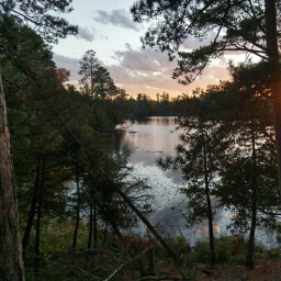
Dogs are allowed on leash. This is one of many Hiking Club trails in the state, which are generally family friendly hikes that showcase some of the best scenery in each Minnesota State Park. This is one of the longer Hiking Club trails, so if you aren't officially collecting passwords, you can just hike to Chase Point and back for a 1.8 mile hike. This hike is available all year; the trail is not groomed for skiing during winter, and snowshoeing is permitted everywhere in the park. This is by far the most popular hike in the park (probably because it's also the best hike in the park), so if you want to avoid people, hike in the early morning or early evening. If you are camping at the Chase Point Campground, this trail is only a short walk away, making this an ideal sunset hike (as you can also see in the photo at the top of the page).
I'm going to be honest here, the loop on the west side of the park road is pretty meh when compared to the stunning scenery on the Chase Point Trail on the east side of the park road. At the same time, 1.8 miles isn't much of a hike if you're a frequent hiker. So if you're looking to put some miles on your boots or are collecting Hiking Club passwords the honest way, do the loop. Otherwise, cut to the Chase (Point).
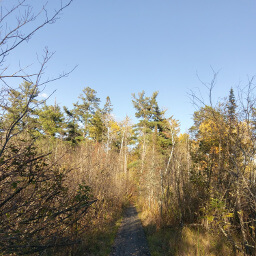
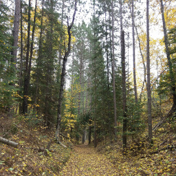
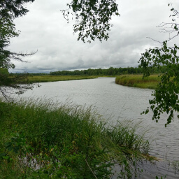
To start the loop, you can either follow the signs pointing away from Chase Point or walk across the street and look for the blue Hiking Club sign -- either way doesn't matter. This trail winds through some decent forest with some gentle ups and downs. At some point you will cross the little wooden boardwalk pictured below. Follow the trail straight the entire time; this trail does intersect with a snowmobile trail, easily identifiable because it is wider than a typical hiking trail, so be sure not to turn there. You will have to cross the road twice on this journey: once near the parking lot and once near the park office. Look for the blue Hiking Club signs to help guide you.
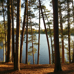
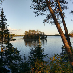
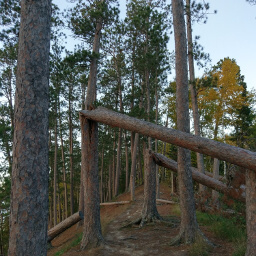
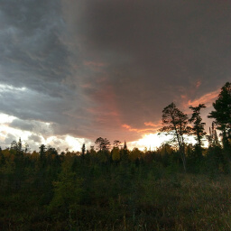
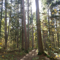
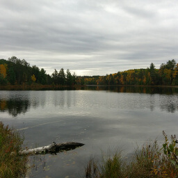
The forest was pretty nice on that little loop before, but you'll notice that the trees on the Chase Point Trail are much larger with more pine. That's because this is one of the few places in Minnesota with old growth pine forest, thanks to the people of the nearby town of Bigfork wanting to make this area a tourist destination. Their efforts mean you can see the Minnesota state tree, the red pine, in all its glory, like the lakeside stand in the picture below. In addition to red pine, you will also see white pine, white spruce, balsam fir, and white cedar. It is important to note that I knew almost nothing about trees until I read the excellent educational signs on this hike; these signs are placed adjacent to the tree they name and describe the distinguishing features. Out of all the hikes I've done, these were the best educational signs yet. The special thing about this hike is that you are walking on top of an esker, a word you've probably never heard unless you paid close attention in geography class. This entire park was once covered by a glacier; however, underneath that glacier was a river that deposited sediment over many years forming the skinny ridge of a peninsula you walk on today. While you enjoy the excellent waterfront views on both sides of the trail, like of Zaiser Island pictured below, think about the giant block of ice that melted for you to have this experience. This trail wouldn't have nearly the same effect if you were walking at water level the entire time. Near the end of the trail, you will see evidence of strong storms damaging the trees. At one point, there's even a sort of tunnel of fallen trees, as shown in the picture below. Once you reach the end of the trail, there will be a brand new staircase (ironically built out of red pine) leading down to the water to give you 180 degree views. Turn around when you're done absorbing the sights of Chase Point. Take your time to enjoy the sights on the return trip, like the sunset through the trees I captured in the picture below. Once I returned to the parking lot, I couldn't help but take another photo of the colorful sunset (see picture below). All in all, this was a thoroughly scenic hike. Seeing the beauty of the Chase Point Trail is half the reason to make the trek to this state park, truly a destination you shouldn't miss. Let me know what you think in the comments section below, and be sure to use #nocoastbestcoast on Twitter and Instagram!
Directions
From Grand Rapids, take Minnesota Highway 38 North, then turn right onto County Road 49 (Wabana Road). This road eventually changes name to Scenic Drive. At the T intersection ahead, turn left onto Scenic Highway. Watch for a sign on the right for Scenic State Park, then turn right on County Road 75 to enter the park. You will pass the parking area for the hike on the right side, but you must continue straight to the park office to purchase a vehicle permit. Once you have your permit, turn around and park in the small lot now on the left side of the road.
Google Maps Directions
Parking, Fees, and Facilities
Like all Minnesota State Parks and Recreation Areas, you must pay a vehicle entry fee of $7 per day or $35 for an annual pass (highly recommended if you frequently go to Minnesota State Parks). There are no facilities at this lot.
Nearby Hikes
Chippewa National Forest, Minnesota
★★★★★(5/5)
McCarthy Beach State Park, Minnesota
★★★☆☆(3/5)
McCarthy Beach State Park, Minnesota
★★★★☆(4/5)
Schoolcraft State Park, Minnesota
★★★★★(5/5)