| Rating | ★★★☆☆(3/5) |
| Overall Difficulty | Easy |
| Navigation Difficulty | Easy |
| Distance | 2.8 miles roundtrip |
| Time | 1.5 hours |
| Terrain | A few hills |
| Best Seasons | All |
| Family Friendly | Yes |
| Dog Friendly | Yes |
| Accessible | No |
Highlights
- Beautiful coastal views of Puget Sound and the Olympic Mountains
- Densely forested park within Seattle city limits
Hike Summary
Discovery Park is Seattle's largest park, and the Loop Trail is a designated National Recreation Trail that circles this urban beauty. The trail is generally wide and flat, and signposts at every intersection point the way for the Loop Trail. Most of the trail travels through a thick forest like pictured below. If you're new to the area like me, you'll be amazed at how moss covers seemingly every surface.

A massive, gnarly tree covered in moss

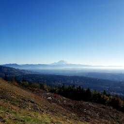
Clouds obscure the Olympic Mountains

Puget Sound from the Loop Trail
Important Information
Dogs are allowed on leash. This flat, wide trail is great for the entire family. You can visit in any season, though views are best on a clear day. Expect to see many people on the hike unless you are hiking very early in the morning.
Directions
Located on the far western edge of Seattle in the Magnolia neighborhood, Discovery Park is not freeway-adjacent. The city streets you use depend heavily on where you're coming from. The urban location also means you can consider using transit or riding your bike. Click the Google Maps link to find the best way.
Google Maps Directions
Parking, Fees, and Facilities
Parking is free! There are restrooms in the visitor center. If this lot is full, there are two other parking lots or you can park on the street -- since this trail circles the entire park, you can access it easily from anywhere.
Nearby Hikes
West Tiger Mountain Natural Resources Conservation Area, Washington
★★★★☆(4/5)
Wallace Falls State Park, Washington
★★★★☆(4/5)