| Rating | ★★★★☆(4/5) |
| Overall Difficulty | Easy |
| Navigation Difficulty | Easy |
| Distance | 2.5 miles roundtrip |
| Time | 1.5 hours |
| Terrain | Mostly flat |
| Best Seasons | All |
| Family Friendly | Yes |
| Dog Friendly | Yes |
| Accessible | No |
Highlights
- Views of the surrounding bluffs
- Variety of landscapes
Hike Summary
Great River Bluffs State Park is one of those parks that I've seen on many lists, yet I haven't met many people who have been to it. Unlike most hikes in hilly bluff country, this trail is mostly flat yet still provides you the amazing views you expect in this area. This hike is the centerpiece of the park, a family-friendly affair that introduces you to the lovely nature found in this part of the state.
The trail starts alongside a restored prairie, as pictured below, with forest on the other side. Pay attention to the variation in vegetation as you transition from one part of the trail to the next; these various zones showcase the past, present, and future of the landscape. As described on a few interpretive signs along the way, the forest used to be an oak savanna, an environment of prairie grasses with big oak and hickory trees that covered southeastern and central Minnesota before human settlement, a gradual transition from the Great Plains to the forests of the east. The prairie to your left represents the first step in transformation of this land to its original state.

The tall grasses of the restored prairie near the start of the trail

The orderly rows and needle-strewn ground of the pine plantation

Wildflowers and green bluffs to the west of the trail

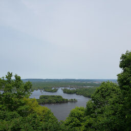
Overlooking the lush Mississippi River Valley with bare Queen's Bluff on the right
Important Information
Dogs are allowed on leash. As a part of the kid-oriented Hiking Club, this is an excellent hike for families. You can hike this trail in any season, including winter; fall colors here are particularly amazing thanks to the topography and overlooks here and throughout the park. I visited on a Monday and saw several people, so I would expect to see many more especially because the park is only an hour from Rochester and 2 and a half hours from the Twin Cities.
Directions
From the Twin Cities, take U.S. Highway 52 south towards Rochester. Take the exit for Interstate 90 heading east towards La Crosse. Take the exit for County Highway 12, turn left, then turn right on County Highway 3. Turn right on Kipp Drive and continue into the park. Pay the entrance fee, then continue straight. Park in the dirt lot on the left side of the road.
Google Maps Directions
Parking, Fees, and Facilities
Vehicle permits are $7/day or $35/year (the annual pass pays for itself after 5 visits!). There are no facilities at this lot, but restrooms are available at the picnic area or campground further down the road.
Nearby Hikes
Great River Bluffs State Park, Minnesota
★★★★☆(4/5)
Forestville-Mystery Cave State Park, Minnesota
★★★★☆(4/5)
Forestville-Mystery Cave State Park, Minnesota
★★★★☆(4/5)
Forestville-Mystery Cave State Park, Minnesota
★☆☆☆☆(1/5)