| Rating | ★★★★☆(4/5) |
| Overall Difficulty | Hard |
| Navigation Difficulty | Easy |
| Distance | 6.6 miles roundtrip |
| Time | 3.5 hours |
| Terrain | Hilly |
| Best Seasons | Spring, Summer, Fall |
| Family Friendly | No |
| Dog Friendly | Yes |
| Accessible | No |
Highlights
- Long, challenging hike
- Wonderful forest and variety of landscapes
Hike Summary
Unlike much of the Midwest, hiking in Wisconsin often involves climbing some hills! I chose this trail specifically because the official map labeled this hike as "advanced" difficulty (bring it on Wisconsin). While this isn't a climb up a mountain, you will be tired and have definitely earned the copious beer, cheese, and brats you will inevitably consume afterward. The proximity to Interstate 94 is a blessing and a curse: this hike is a really easy escape from Milwaukee but you will hear the road noise throughout the hike. However, the nature itself is well preserved in this park and the scenery is pretty enough that you will forget about the noise.
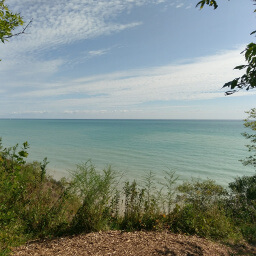
Start your journey by walking up the hill and climbing to the top of the observation tower -- you are not going to want to ascend all those stairs after you finish this long, hilly hike. Lapham Peak is the tallest point in Waukesha County, and climbing to the top of the 45 foot tall observation tower will give you a commanding view of Southwestern Wisconsin, pictured below (according to one bystander at the top of the tower, you can see Lambeau Field in Green Bay on an especially clear day). Near the bottom of the observation tower, there will be a trail with several long steps marked as the Ice Age Access Trail. Follow this to a wide, grassy trail and head south to the next intersection. Here, you can choose to go either left or right since the trail is a loop. To the left, the trail is hillier and almost entirely under the forest canopy. To the right, the trail has more flat sections and travels along open prairie. I suggest going left first to do the longer and more difficult half of the trail while you have energy.

The view from the top of the observation tower on Lapham Peak

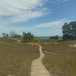
The trail heading downhill through dense forest

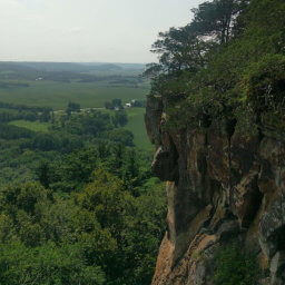
A field of goldenrod with the hills in the background

Meadow nestled between a pine forest
Important Information
Dogs are allowed on leash. During the winter, this trail is designated for skiiers only but you may hike in the other three seasons. This trailhead is extremely popular, and you may have difficulty finding a parking spot on a weekend during peak times -- I highly recommend arriving early in the morning or late in the afternoon (the park is open until 9pm year round) to beat the crowd. Despite the difficulty of this particular route, you will see many people during your hike due to portions of the trail being shared with other routes and many opportunities to shorten the journey. This route is not family friendly, but I saw many families on the trail presumably doing another route or just a portion of this trail; for a flat, easy trail try the Meadow Trail or do the Kame Terrace Trail to see the butterfly garden.
Directions
From Milwaukee, head west on Interstate 94 to Delafield. Take the exit for County Road C, then turn right. Following signs for Kettle Moraine State Forest, turn left onto the main park road. Pay your fee, then continue to the parking lot at the road's end.
Google Maps Directions
Parking, Fees, and Facilities
If you have Wisconsin license plates on your vehicle, parking is $8 for the day or $28 for an annual pass valid at all Wisconsin State Parks and Forests. If you are from out of state, parking is $11 for the day or $38 for an annual pass (you recoup your cost after just 4 visits!). See details here. This is a popular trailhead and the parking lot may be full on weekends during peak times. There is an another parking lot a short walk away, otherwise you can park at the Homestead Lot and start the trail from a different trailhead. There are pit toilets and a drinking foutain as well as several picnic tables near the trailhead.
Nearby Hikes
Lion's Den Gorge Nature Preserve, Wisconsin
★★★★☆(4/5)
Rock Cut State Park, Illinois
★★★☆☆(3/5)
Kohler-Andrae State Park, Wisconsin
★★★★★(5/5)
Gibraltar Rock State Natural Area, Wisconsin
★★★★★(5/5)