| Rating | ★★☆☆☆(2/5) |
| Overall Difficulty | Easy |
| Navigation Difficulty | Easy |
| Distance | 3.5 miles roundtrip |
| Time | 1.5 hours |
| Terrain | Mostly flat |
| Best Seasons | Spring, Fall |
| Family Friendly | No |
| Dog Friendly | Yes |
| Accessible | No |
Highlights
- An escape from the typical Midwestern landscape
- Short drive from the Twin Cities
- Great for solitude on the trail
Hike Summary
I'll be frank here, if you drive to this trail hoping to see towering mounds of sand like the Sahara, you will be extremely disappointed (you'll need to drive to Indiana or Michigan if you crave something closer to the real thing). However, if you arrive with a desire to see a different landscape that you wouldn't expect in this part of Minnesota, you will leave satisfied.
The trail begins just beyond the sign and gate restricting vehicular access, just follow the sandy tracks into the forest. Once the car is out of sight, you'll take a look around you and realize that this sandy forest is what they meant when they named it "dunes". Eventually on your right you will see the results of clearcutting -- what many people don't realize is that the main purpose of state forests is preserving and maintaining land for logging and not recreation. This was truly an alien sight to me in this part of Minnesota. The bare dirt littered with tree branches and pine needles resulting from logging looked more like a scene in the mountains in the Southwest.

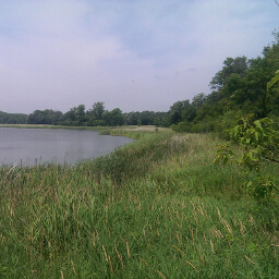
The sandy trail and pine forest of Uncas Dunes

The typical landscape within Uncas Dunes Scientific and Natural Area.
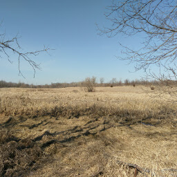
Turn left at the T intersection. In this section, you will see dense pine forest, completely devoid of vegetation growing underneath the canopy, with a floor littered in dead pine needles. Again, this is a sight I never expected to see in Minnesota.

A pine forest that feels much more like the mountains in the Southwestern U.S.
When the trail meets with the road, go left and continue along the side of the road until you reach the parking area. If you are feeling hot and sweaty after finishing, head over to the Bob Dunn Recreation Area within Sand Dunes State Forest by heading west on County Road 10, turning right onto County Road 5, then turning right on North Sand Dunes Forest Road (there should be a brown sign telling you to turn right here). Follow the signs for the beach and enjoy! Connect with me using the social media links below and share your adventures!
Important Information
This trail is definitely off the beaten path, even though it is not remote -- there are houses across the street from the trailhead. Even on a Saturday, there wasn't a single soul on the trail. Routefinding is easy since the trail is technically a road. Feel free to bring your dog; I couldn't find any rules on the official State Forest site (see link at bottom) about dogs, but State Forests are generally less restrictive than most public lands.
Directions
From the Twin Cities, take Interstate 94 north towards St. Cloud, and take the exit for Minnesota Highway 101 towards Elk River. Then, take the exit for U.S. Highway 10 going north. Continue on U.S. 10, then turn right at County Road 15. Turn left at County Road 10 (also called 237th Ave). Watch for a sign for 176th St. on the left side of the road and turn right onto a short dirt road, which is a continuation of 176th St. You are likely to miss this if you don't pay attention (I missed it myself)! Park off to the side where the road ends.
Google Maps Directions
Parking, Fees, and Facilities
Free parking, located in a tiny, overgrown dirt lot just off County Road 10. Although you may likely be the only one parked here and it may not look like somewhere you are allowed to park, this is indeed indicated as a parking area on the official State Forest map
Nearby Hikes
Lake Maria State Park, Minnesota
★★★★☆(4/5)
Elm Creek Park Reserve, Minnesota
★★★☆☆(3/5)
Elm Creek Park Reserve, Minnesota
★★★☆☆(3/5)
Baker Park Reserve, Minnesota
★★☆☆☆(2/5)