| Rating | ★★★★★(5/5) |
| Overall Difficulty | Moderate |
| Navigation Difficulty | Easy |
| Distance | 4.1 miles roundtrip |
| Time | 2 hours |
| Terrain | Hilly |
| Best Seasons | Spring, Fall |
| Dog Friendly | No |
| Accessible | No |
Highlights
- One of the most scenic trails in the entire North Unit
- Badlands views throughout the entire hike
- Few people and good opportunities for wildlife viewing
Hike Summary
There is no doubt that the Caprock Coulee Loop is one of the best moderate length hikes (if not the best) in all of Theodore Roosevelt National Park. The trail starts by meandering through a canyon with beautiful badlands rock formations before climbing to the top of a prairie plateau with occasional viewpoints. At the end of the hike, the trail traverses a ridge and you can turn your head in either direction for astounding views. This is absolutely a must do hike if you make it to the North Unit of the park.
Follow the trail leaving from the Caprock Coulee parking area to do the loop in a counterclockwise direction -- this allows you to finish the hike with the fantastic ridge views and a long descent back to the parking lot. Turn left at the intersection ahead, and be sure to sign the trail register before embarking on your journey! When I passed through here, a ranger was explaining to another group of hikers that the register is the only way the park can track trail usage and helps them better plan and maintain the trails. From the intersection and beyond, the trail is mostly flat with a slight bit of uphill as it enters a narrow badlands canyon, as pictured below.

The Caprock Coulee Nature Trail leading into the badlands

Looking back into the badlands during an ascent

Brackish water pooling on the steps

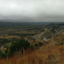
Fall colors at the bottom of the endless canyon

Bison grazing on top of the plateau

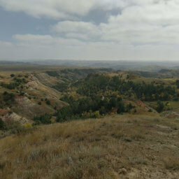
Caprock Coulee Trail as it extends across the plateau

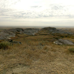
This view is even better than the one at River Bend Overlook

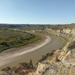
Looking back at the Little Missouri River at the bottom of the canyon
Hiked on Sunday, September 16th, 2018 by Ricky Holzer
Important Information
Dogs are prohibited on all trails in Theodore Roosevelt National Park. The entire loop is too difficult for a family hike, but those with kids can certainly do the segment of the loop labeled the Caprock Coulee Nature Trail. Fall and spring are the two best seasons for this trail; summer heat on this shadeless route would be uncomfortable in addition to the propensity for thunderstorms, and icy conditions in winter would make the steeper portions extremely dangerous. You will definitely encounter others on the Nature Trail portion of the loop, but few attempt the entire loop despite it's tremendous beauty.
Directions
From Interstate 94, take the exit for U.S. Highway 85 in Belfield and head north, following signs for the North Unit of Theodore Roosevelt National Park. In a little over 50 miles, you'll see signs for the park entrance. Turn left and pay the park entrance fee at the station or by entering the visitor center on the right if the entrance station is closed. Continue on the scenic drive, traveling slowly to absorb the beautiful scenery and to get a taste of what's to come. Watch for signs for the Caprock Coulee Trail and park in the lot on the right side of the road. You can also park at the River Bend Overlook -- you'll just be starting the loop at a different location.
Google Maps Directions
Parking, Fees, and Facilities
Entrance to the park requires paying the $30 vehicle entrance fee valid for 7 days, except on designated fee free days. Annual passes for Theodore Roosevelt National Park are also available at $55. Interagency annual passes are available for $80 with discounts for seniors, military, and those with disabilities. Visit the Theodore Roosevelt National Park webpage about fees for more detailed information. There are no facilities available near the lot.
Nearby Hikes
Theodore Roosevelt National Park, North Dakota
★★★★☆(4/5)
Theodore Roosevelt National Park, North Dakota
★★★★☆(4/5)
Theodore Roosevelt National Park, North Dakota
★★★★★(5/5)
White Butte, North Dakota
★★★★★(5/5)