| Rating |
★★★★★(5/5) |
| Overall Difficulty |
Hard |
| Navigation Difficulty |
Easy |
| Distance |
8.6 miles roundtrip |
| Time |
5 hours |
| Terrain |
Strenuous climbing, 1300 feet of elevation gain |
| Best Seasons |
Spring, Summer, Fall |
| Family Friendly |
No |
| Dog Friendly |
Yes |
| Accessible |
No |
Highlights
- Breathtaking views along the trail
- Hiking a portion of the Appalachian Trail
- Seeing wild ponies
Hike Summary
Mount Rogers is the highest mountain in Virginia and the only state highpoint in the Southeast that requires a significant hike to summit. Though the over 8-mile hike is a challenge, it is worth every single step you take. To say the views are abundant is an understatement, and you will feel like you're on top of the world for a majority of the trip. Undoubtedly, this was one of my favorite hikes this year.
Starting from the Massie Gap Trailhead, go through the gate and start hiking up the Rhododendron Trail. This trail was named for the pink flowering plant that grows high in the Appalachians and blooms in the summer, as pictured below. Also notice that in contrast to the thick forest found on all the other state highpoints in the Southern Appalachians, most of the trail to Mount Rogers is on a grassy bald, where the extreme weather and soil conditions prevent trees from growing. Most of the greenery on this hike won't be much taller than you, meaning there are plenty of views.

Rhododendrons blooming and Appalachian views
In addition to the ample scenic beauty of the hike, you're likely to see wild ponies like pictured below, especially near the start of the trail. Though not native to the area, the ponies were introduced to the park to control the growth of trees and preserve the grassy balds. You may also encounter cows during the hike, who serve a similar purpose to the ponies. As with any wild animal, keep your distance for your safety, even though the ponies are accustomed to people -- locals have been known to pet and feed the ponies.

Wild ponies grazing near the trail
When the Rhododendron Trail intersects with the Appalachian Trail, turn left (there will be a wooden post indicating each trail). The trail is slightly flatter for a while until you reach another gate and the trail register. Sign your name in the book here so rangers can help rescue you in an emergency and to help park managers track how many people use the trail. From this point on, the trail will be rough, steep, and rocky and white rectangles sprayed on rocks and trees will mark the way. Your painstaking climbing will soon yield wonderful views to the east, as pictured below.

Views to the east after gaining some elevation
The trail ascends, and you'll pass through a mini cave before reaching the crest of a hill. After a short descent, you'll cross a grassy bald (this is where I saw cows) before climbing again. You'll have your first views of the rounded summit of Mount Rogers in the distance, as pictured below.

The trail through a grassy bald with the rounded top of Mount Rogers in the distance
Shortly, the Appalachian Trail will intersect with the Crest Trail. Signage here is a little confusing, but stay on the Appalachian Trail and the white blazes will let you know you're on the right path. This rocky area is one of the few spots on the hike with northerly views, as pictured below.

This section of the Appalachian Trail makes you feel like you're on top of the world
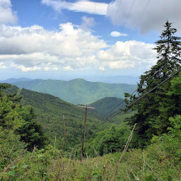
Beyond the intersection with the Crest Trail, you'll enter into a shady forest -- the trail in this part is often muddy since it sees little sun. After a small descent, you'll emerge into some absolutely stunning views, as pictured below. You'll also pass through a trail camp, where through-hikers of the Appalachian Trail rest their tired feet for the night.

Incredible views along the Appalachian Trail looking toward the high peaks in North Carolina
After enjoying some of the best views on the hike, you will meet the Mount Rogers Trail you will take to the summit. Following a bit of climbing, the landscape will change drastically from the open, grassy bald to a damp, mossy, fern-covered forest, as pictured below. In fact, Mount Rogers is the northernmost of the only 6 areas in the U.S. where you can find this type of spruce-fir forest.

The wet, mossy forest on the top of Mount Rogers
Despite the challenging climb and long distance, the summit is anticlimactic -- a flat space buried in a spruce forest. In fact, I would've missed the summit marker altogether if another hiker didn't point it out to me! Unlike the celebratory signs on the tops of other state highpoints, the only marker on Mount Rogers is a USGS disc embedded into a rock, as pictured below. It's fitting that a rock marks the summit of a mountain named for the first State Geologist of Virginia, William Barton Rogers (who also founded MIT).

The USGS disc is the only thing marking the summit of Mount Rogers
Now that you've summitted, remember you're only halfway done with the hike! Continue back the way you came, and triumphantly savor the many, many views on the way down. Enjoy the hike and connect with me using the social media links below and share your adventures!
Important Information
Dogs are allowed on leash, but know that you may encounter wild ponies or cows along the trail. While the entire trip to the top of Mount Rogers is too difficult for a family hike, many families hike the Rhododendron Trail to its intersection with the Appalachian Trail; this route is still quite scenic and ends at a nice view. Spring through fall is the best time to hike; winter brings snow and bad weather that may make hiking difficult or impossible. Massie Gap is a hugely popular trailhead and this is the most popular route to the summit. Expect to see many people when you hike, though the numbers thin once you start on the Appalachian Trail.
Directions
The Massie Gap Trailhead in Grayson Highlands State Park is an hour away from Interstate 81. Use the Google Maps link below to navigate the rural highways to get here.
Google Maps Directions
Parking, Fees, and Facilities
Entrance into Grayson Highlands State Park is $7 per vehicle or $10 per vehicle on weekends and holidays April-October. There are pit toilets near the parking area.
Nearby Hikes
External Links