| Rating | ★★★★☆(4/5) |
| Overall Difficulty | Moderate |
| Navigation Difficulty | Easy |
| Distance | 2.8 miles roundtrip |
| Time | 1.5 hours |
| Terrain | Strenuous climbing, 800 feet of elevation gain |
| Best Seasons | Spring, Summer, Fall |
| Dog Friendly | Yes |
| Accessible | No |
Highlights
- Climbing the highest mountain east of the Mississippi
- Panoramic views at the summit
Hike Summary
You might expect the highest peak east of the Mississippi to be a difficult place to reach, but you can drive almost all the way to the top and walk a short distance on a paved path to the overlook. Having done this recently on the state highpoints in Georgia, South Carolina, and Tennessee, I wanted a bit more of a hike. The Old Mitchell Trail is the perfect alternative since it is relatively short but still long enough to make you feel like you earned your view at the end. You'll also get to experience more of the unique forest that only grows on the tops of the highest peaks in the Southern Appalachians.
The trail starts on the east side of the parking lot near the restaurant. You'll immediately start climbing uphill, though the trail is more gradual and well-graded in comparison to what comes later. Eventually, you'll start a short descent and the trail will become more rugged. The rocks here are almost always wet due to the frequent drizzles and high humidity, so be careful not to slip!
The forest you'll hike through is different from what you'll see elsewhere in the Appalachians. Mount Mitchell is located in the Black Mountains subrange, which was named for the dark color of the spruce and fir trees that only grow on top of the highest mountains, as pictured below. In winter, these evergreen trees starkly contrast the brown of the deciduous trees that grow on lower elevations. Only 6 places in the Southern Appalachians have peaks with this type of forest; you can also find it on the Tennessee and Virginia state highpoints.

Foggy spruce-fir forest on the slopes of Mount Mitchell

The rainforest-like environment makes everything mossy

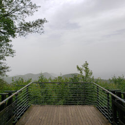
Trailside views to the east thanks to a clearing for powerlines

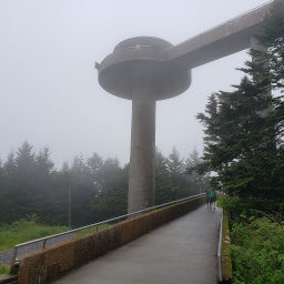
The sign and observation platform on top of Mount Mitchell

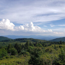
The view to the north from the summit of Mount Mitchell
Hiked on Monday, June 29th, 2020 by Ricky Holzer
Important Information
Dogs are allowed on leash. The Old Mitchell Trail is steep and rocky; the more family-friendly option is to drive most of the way to the top and take the paved trail to the summit. Spring through fall is the best time to visit since winter weather often closes Blue Ridge Parkway. Most people opt to drive up Mount Mitchell, so you will some have moments of solitude on this trail.
Directions
Mount Mitchell State Park is about an hour from Asheville. From Asheville, take North Carolina Highway 694/Town Mountain Road to Blue Ridge Parkway, then turn left. Follow the scenic, winding road to North Carolina Highway 178 and turn left -- there will be signs for the state park. Park in the lot for the restaurant.
Google Maps Directions
Parking, Fees, and Facilities
Parking is free! There is a restaurant and restrooms near the lot.
Nearby Hikes
South Carolina
★★★☆☆(3/5)
Great Smoky Mountains National Park, Tennessee
★★★★☆(4/5)
Grayson Highlands State Park, Virginia
★★★★★(5/5)
Kentucky
★☆☆☆☆(1/5)