| Rating | ★★★★☆(4/5) |
| Overall Difficulty | Moderate |
| Navigation Difficulty | Easy |
| Distance | 5.5 miles roundtrip |
| Time | 2.5 hours |
| Terrain | Hilly |
| Best Seasons | Spring, Summer, Fall |
| Family Friendly | No |
| Dog Friendly | Yes |
| Accessible | No |
Highlights
- Mossy logs straddling an intermittent creek
- Short drive from the Twin Cities
- Less crowded than other hikes in the park
Hike Summary
Other than Fort Snelling, this is the closest state park to the Twin Cities and is definitely worth a visit. The park has some nice nature without the highway noise of similar locations within the Twin Cities. The trail system here is quite extensive, so you could return to this park several times and never have to do the same hike twice! Like most hikes in Minnesota state parks, dogs are allowed on leash. This particular hike is too long and hilly to be considered family friendly; however, many families hike the 0.8 miles to the beach on the St. Croix River, and the Hiking Club loop is a perfect option for kids capable of a 2 mile hike.
Upon arriving, I was quite surprised at both the size of the parking lot and the number of cars parked there. However, don't be fooled into thinking this hike will also be crowded -- most day hikers just take a short walk to the beach. Also note that all of the campsites here are hike in, and thus anyone camping is also parked in this lot.
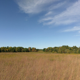
From the parking lot, walk past the nature center and head south on the paved trail. There will be a short, looping interpretive trail on the right if you want to learn more about the prairie you are currently walking through. After about a three quarters of a mile, there will be a junction with an unpaved trail. Stay on the paved trail here, then at the next junction in 0.2 miles, take the unpaved trail heading to the left.
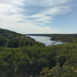
From this point on, the trail will become hilly and narrow, winding through the forest next to an intermittent creek -- it was dry when I visited, but is likely to be flowing after a heavy rain. The creek is full of mossy logs and is a pleasant (but not very photogenic) sight. In a little over three quarters of a mile, there will be a split in the trail. Head left and take the loop. If you read the trail highlights on the official park map, it mentions that this particular loop climbs to the top of a bluff with "expansive views". That is misleading. In reality, you hike to the top of a hill with most of your view blocked by the forest with the only remaining view being farmland. Perhaps this area has better views in early spring or late fall when the foliage isn't as dense.
Continue hiking around the loop, then at the intersection with the main trail, turn left. After 0.4 miles, take the trail going underneath the bridge. In half a mile after climbing to the top of a hill, turn left at the T intersection. At the next intersection, continue going straight rather than veering to the right. From here on, follow the signs for the Hiking Club trail.
Stay straight at the next intersection, then turn right at the following intersection as directed by the Hiking Club sign. In just over 0.1 miles, you will come to an intersection of many trails. If you have energy for an additional 0.4 miles, turn left and follow the signs to the swimming area (there are also pit toilets by the swimming area if you need to use the facilities). Otherwise, turn sharply to the right and head back towards the parking lot, crossing over the bridge pictured below.
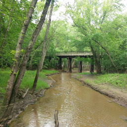
Hike over this bridge in Afton State Park
View full size
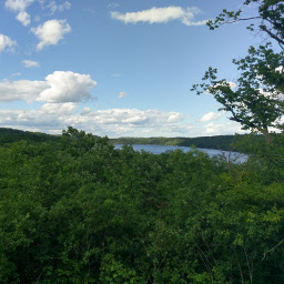
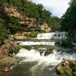
Overlooking the St. Croix River
View full size
Directions
From Minneapolis or St. Paul, take Interstate 94 east towards Hudson, then exit at Minnesota Highway 95/Manning Avenue and head south. Turn left onto 70th Street -- there should be a sign at this intersection pointing you to Afton State Park.
Google Maps Directions
Parking, Fees, and Facilities
Like all Minnesota State Parks and Recreation Areas, you must pay a vehicle entry fee of $7 per day or $35 for an annual pass (highly recommended if you frequently go to Minnesota State Parks). The parking lot is gigantic and is adjacent to a nature center and bathrooms. All of the trails in the park start from this parking lot.
Nearby Hikes
Kinnickinnic State Park, Wisconsin
★★★☆☆(3/5)
Kinnickinnic State Park, Wisconsin
★★★★☆(4/5)
Willow River State Park, Wisconsin
★★★★☆(4/5)
Battle Creek Regional Park, Minnesota
★★★☆☆(3/5)