| Rating | ★★★★☆(4/5) |
| Overall Difficulty | Easy |
| Navigation Difficulty | Easy |
| Distance | 4 miles roundtrip |
| Time | 2 hours |
| Terrain | A few hills |
| Best Seasons | All |
| Dog Friendly | Yes |
| Accessible | No |
Highlights
- Picturesque waterfall in a rocky gorge
- Overlooks to escape the crowds
- Swimming on hot days
Hike Summary
One thing I've learned about the Midwest is that there are plenty of waterfalls, and unlike the west these waterfalls always have water flowing. This hiking experience to Willow Falls reminded me of waterfall hikes I've done in Southern California (scenery aside): this hike had one of the most diverse crowds I've ever seen on a trail in the Midwest, the falls were swarming with people, and families with strollers were everywhere. I went on a hot Sunday afternoon, and I can guarantee you that this park is never empty on a nice day. If you're looking for a less crowded waterfall for a day hike, I suggest going to Wolf Creek Falls in Banning State Park (although it's not nearly as close to the Twin Cities as Willow Falls State Park).
Dogs are allowed on leash on the trail, but not in the picnic area. This hike is the definition of family friendly, and your kids will not pass up an opportunity to play in the falls. During the summer, I highly suggest bringing your bathing suit (wear it if you can bear hiking in it -- there isn't anywhere to change at the falls); swimming is essential to the experience here.
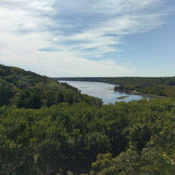
If you haven't been to the park recently, you'll notice one glaring difference: the lake is gone (one guy came up to me and said he was here 4 years ago and remembered a lake and asked me where to find it). The dam that created the lake needs replacement, so it has been removed (see picture below), leaving a sea of greenery and little river where the lake once was. If you're interested, the Nature Center has a timeline showing the history of the dam leading up to its destruction. It may take a while to procure funding to rebuild the dam, and one sign said 2020 is the earliest to expect the lake to return. If you would like to see the ruins of the dam and Little Falls, follow the paved trail north through the picnic area for a short distance.
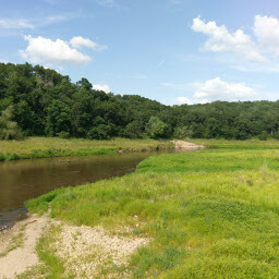
Willow River running where the lake once was
View full size
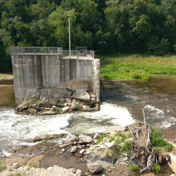
The remnants of the dam
View full size
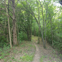
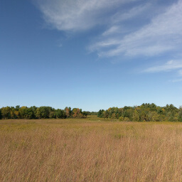
Once through the campsite, take a left turn onto the unpaved trail. You will follow this meandering trail through the forest until you reach the falls. Take advantage of the breaks in the trees on the left side to enjoy views of the "lake" like shown in the image below. There are some downhill portions on this stretch that you will most likely forget about, then suddenly remember when you have to climb back up them on the return trip.
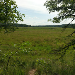
Viewing the empty lake from the trail
View full size
To head back, follow the trail back the way you came. There will be a split in the trail not far from the falls that you might not have noticed on the way there. Veer to the right here, away from the paved trail that heads uphill. The remainder of the hike should be familiar.
After doing this hike, you will understand why the falls are so popular: this is the perfect summer destination close to the Twin Cities. Take advantage of the missing lake while you can and see the interesting grassland that grows in its place!
Hiked on Sunday, July 30th, 2017 by Ricky Holzer
Directions
No matter how many times I drive to Wisconsin, it baffles me how close it is to the Twin Cities (and that many people commute from Wisconsin daily). From the Twin Cities, take Interstate 94 east towards Hudson. Take exit 4 for U.S. Highway 12, then follow this road straight for about 4 miles -- the name of this road changes from U.S. 12 to County U to County A but you don't have to turn or merge at all. Watch for the park entrance on the left, turn, then pay the fee at the park office (at least in the warmer months, they operate a drive up window so you don't have to leave your car). Follow the main park road, and eventually turn right to park in the lot by the Nature Center.
Google Maps Directions
Parking, Fees, and Facilities
If you have Wisconsin license plates on your vehicle, parking is $8 for the day or $28 for an annual pass. If you are from out of state, parking is $11 for the day or $38 for an annual pass. See details here. The parking lot by the Nature Center is large and paved, with many picnic tables and benches. There are flush toilets in the warmer months and pit toilets in the colder months. The Nature Center itself should have at least one staff member who can provide you information and maps, and there is an exhibit area with live animals (smaller ones like turtles, Monarch caterpillars, and frogs) and fake animals native to the area.
Nearby Hikes
Afton State Park, Minnesota
★★★★☆(4/5)
Kinnickinnic State Park, Wisconsin
★★★☆☆(3/5)
Kinnickinnic State Park, Wisconsin
★★★★☆(4/5)
William O'Brien State Park, Minnesota
★★★☆☆(3/5)