| Rating | ★★★★☆(4/5) |
| Overall Difficulty | Moderate |
| Navigation Difficulty | Easy |
| Distance | 3.2 miles roundtrip |
| Time | 1.5 hours |
| Terrain | Hilly |
| Best Seasons | All |
| Family Friendly | No |
| Dog Friendly | Yes |
| Accessible | No |
Highlights
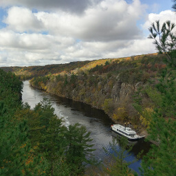
- Several impressive viewpoints of the St. Croix River
- Escape the crowds near the glacial potholes
- Leg burning ascent to overlooks
Hike Summary
The Minnesota side of Interstate State Park isn't very large, and with this hike you will travel almost every mile of trail in the entire park. Despite its small size, there is ample natural beauty. With five overlooks and several interpretive signs, you can absorb this beauty while learning more about it.
Dogs are allowed on leash. The River Trail is part of the Hiking Club program, a series of easy to moderate difficulty trails with a sign containing a secret password; this program is perfect to introduce kids to hiking. If you cut out the portion of this route on the Sandstone Bluffs Trail, which has a few giant staircases, this hike can be a family friendly 3 miles. Otherwise, stick to area by the glacial potholes. This route is available in all four seasons. Given the proximity of the park to the Twin Cities, it can be quite crowded on a nice day, especially near the glacial potholes. The further you hike, the fewer people you will see.
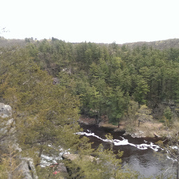
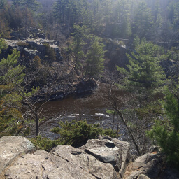
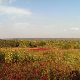
From the parking lot, follow the River Trail, which starts right by the drinking fountain and should be labeled with a blue Hiking Club sign. As expected, the trail curves alongside the river with some occasional uphill and downhill. One downside to this trail is that it parallels U.S. Highway 8, so it's not the peaceful nature walk you might have hoped for. Nevertheless, the road noise does not take away from the beauty of the St. Croix River from the several overlooks on top of the bluffs along the trail, as pictured at the top of the page and below.
The Sandstone Bluff Trail is quite the workout, with several tall staircases to ascend to the top of the hills. It's also an interpretive trail, so in addition to some impressive views, you can also learn something about the area from educational signs. Fortunately, the staircases and trail has strategically placed benches for you to catch your breath. Eventually, the trail reconnects with the Railroad Trail and you can turn left to begin your return to the parking lot.
The Railroad Trail is mostly flat, a reprieve from the struggles on the previous trail. As you probably expected, this was a former rail route that was converted to a recreational trail. Near the end of the trail, you will pass the historic train depot. The trail ends in Taylors Falls, and you will have to turn right and follow the city sidewalks to return to the parking lot. I hope you enjoyed seeing all of Interstate State Park! Let me know what you think in the comments section below, and be sure to use #nocoastbestcoast on Twitter and Instagram!
Directions
Interstate State Park is located in Taylors Falls, Minnesota on the border with Wisconsin. From the Twin Cities, take Interstate 35 north, then go east on U.S. Highway 8. Normally, you can follow U.S. Highway 8 the entire way to the park, but when I went road construction closed a portion of the highway. If the road is still closed, on U.S. Highway 8 just past Lindstrom, turn left on Andrews Ave. then turn right on Louise Ave. You can contine on this road all the way to Taylors Falls, and signs should direct you to the park once in town. If you cross the river into Wisconsin, you have gone too far.
Google Maps Directions
Parking, Fees, and Facilities
Like all Minnesota State Parks and Recreation Areas, you must pay a vehicle entry fee of $7 per day or $35 for an annual pass (highly recommended if you frequently go to Minnesota State Parks). Parking is in a paved lot adjacent to the visitor center with flush toilets and water.
Nearby Hikes
Interstate State Park, Minnesota
★★★★☆(4/5)
Interstate State Park, Wisconsin
★★★★★(5/5)
Wild River State Park, Minnesota
★★★★☆(4/5)
William O'Brien State Park, Minnesota
★★★★☆(4/5)