| Rating | ★★★★★(5/5) |
| Overall Difficulty | Easy |
| Navigation Difficulty | Easy |
| Distance | 2.4 miles roundtrip |
| Time | 1 hour |
| Terrain | Hilly |
| Best Seasons | All |
| Family Friendly | Yes |
| Dog Friendly | Yes |
| Accessible | No |
Highlights
- Several beautiful overlooks of the St. Croix River from atop bluffs
- Loop around the lake to a swimming beach
Hike Summary
While the Minnesota side of Interstate State Park is nice (especially if you want to see big glacial potholes), the Wisconsin side offers much better views and a wider variety of hiking trails. Even better, there isn't a highway dividing the park that muffles the sounds of nature like on the other side of the river. Here, you can climb to the highest point on the bluffs and observe the majestic rock formations in all their glory. At only an hour from the heart of the Twin Cities, this is one destination you shouldn't miss and is an excellent place to view fall colors.
Dogs are allowed on leash. While the trail to the top of the bluffs requires a bit of climbing, the route is short enough that anyone should be able to do it; skip the loop around the lake if you desire to shorten the hike. Only 2.8 of 12.5 total miles of trail are restricted to cross country skiing in the winter, but there isn't a map on the website specifying which trail doesn't allow hiking. It is doubtful that this route includes that 2.8 miles, so you should be free to hike this route in all seasons. Summit Rock is one of the most popular destinations in the park, so expect to see many people no matter when you go.
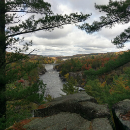
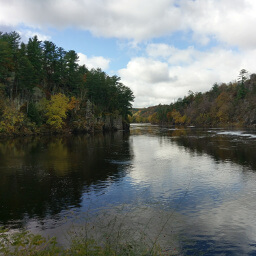
The trail for Summit Rock is signed and starts right by the parking spots on the park road. As expected, there is some uphill required to reach Summit Rock, but the climb ends almost as soon as it begins. At the top, you will be rewarded with a wooden platform providing tremendous views of the St. Croix River, the surrounding bluffs, and Taylors Falls -- see the picture below for one viewpoint from the top.

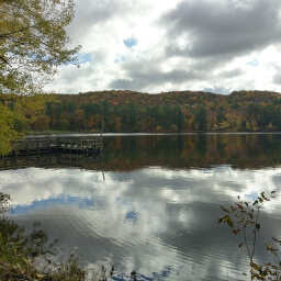
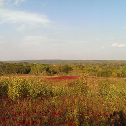
From the top of the bluffs, follow the River Bluff Trail downhill until you reach the Lake O' the Dalles. The trail runs along the road near the lake, until you eventually must walk on or directly to the side of the road for a short distance before meeting the trail again. This is the flattest part of this entire journey, and you will have lovely lakefront views like pictured below. The trail ends at the beach on the Lake O' the Dalles; if it's a nice summer day, you can cool off and swim or just relax in the shade by the water. To return to the parking lot, follow the paved trail uphill. I hope you enjoy this excellent scenic hike on the "better" half of Interstate State Park! Let me know what you think in the comments section below and be sure to use #nocoastbestcoast on Twitter and Instagram!
Directions
From the Twin Cities, take Interstate 35 north and take the exit for U.S. Highway 8 heading east. Shortly after crossing the bridge into Wisconsin, take the exit for Wisconsin Highway 35 (Vincent Street) and turn right. Look for signs for Interstate State Park and turn right. Pay your fee at the office, and continue down the park road. There are a few closer spaces on along the road on the right, otherwise continue down the road and turn left into the large lot.
Google Maps Directions
Parking, Fees, and Facilities
If you have Wisconsin license plates on your vehicle, parking is $8 for the day or $28 for an annual pass valid at all Wisconsin State Parks and Forests. If you are from out of state, parking is $11 for the day or $38 for an annual pass (you recoup your cost after just 4 visits!). See details here. There is a picnic area and flush toilets and pit toilets (depending on the season) near the Lake O' the Dalles beach.
Nearby Hikes

Interstate State Park, Minnesota
★★★★☆(4/5)

Interstate State Park, Minnesota
★★★★☆(4/5)
Wild River State Park, Minnesota
★★★★☆(4/5)
William O'Brien State Park, Minnesota
★★★★☆(4/5)