| Rating | ★★★★☆(4/5) |
| Overall Difficulty | Easy |
| Navigation Difficulty | Easy |
| Distance | 1 mile roundtrip |
| Time | 1 hour |
| Terrain | Hilly |
| Best Seasons | Spring, Summer, Fall |
| Dog Friendly | Yes |
| Accessible | No |
Highlights
- A chance to look above the dense forest canopy
- Panoramic views for miles
Hike Summary
Before the advent of aircraft, fire towers were essential to monitoring forests, especially in the flat environment of the Midwest. Today, many state parks maintain these towers for visitor use, allowing a unique view above the forest canopy allowing you to see for miles in all directions. This particular fire tower is strategically located close to the center of this large park, providing astounding views of the surrounding wilderness without the highways and neighboring towns you may see from towers in other locations.
Dogs are allowed on leash, and given the shortness of this hike, most children should be able to complete it. The only difficult part is the many stairs to climb to the top of this 100 foot tall tower.
The hike is straightforward since this is the only trail leaving from this particular parking lot, so follow the trail south. When you come to a T intersection, turn right and continue until you see the fire tower after a half mile of hiking.
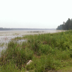
The prospect of panoramic views attracts many people to this hike, and it is not unlikely that you will have to wait in a short line to climb to the top of the tower -- due to the load restrictions of the structure, only a few people can be on the tower at a given time. Hopefully your pictures will be better than mine shown above; there was a wildfire in Canada and the smoke filled the park and clouded my view.
To return to the parking lot, follow the trail back the way you came. Make sure you turn left at the intersection -- the Aiton Heights Trail continues going straight and will lead you deeper into the forest.
Hiked on Friday, July 3rd, 2015 by Ricky Holzer
Directions
Itasca State Park is approximately 4 hours from the Twin Cities. Head west on Interstate 94 towards St. Cloud. In Monticello, take the exit for Minnesota Highway 25, then turn left onto Park Blvd. Turn left onto U.S. Highway 10 and continue on this highway for about 2.5 hours until you reach Verndale. Turn right onto County Road 23. After 15 miles, turn left onto Minnesota Highway 27, then take a quick right onto Hubbard Road/County Road 6. Turn left on Minnesota Highway 87, then turn right on U.S. Highway 71. Continue on this highway for about half an hour, then turn left on Minnesota Highway 200, then left again onto County Road 48, following signs for Itasca State Park. When the road ends at a T intersection, turn right onto Park Rd.
Pay the vehicle entrance fee at the visitor center on the right, then continue heading north on Park Rd. If you haven't been to the Mississippi Headwaters before, be sure to stop on your way to this hike -- you have to pass the parking lot for it anyway. Because Wilderness Drive, the road connecting to this trailhead, is one-way, you will have to follow the main park road in a long circle before finding the turnoff on the right hand side -- it's easy to miss, so slow down and pay close attention once you're on the one-way road.
Google Maps Directions
Parking, Fees, and Facilities
Like all Minnesota State Parks and Recreation Areas, you must pay a vehicle entry fee of $7 per day or $35 for an annual pass (highly recommended if you frequently go to Minnesota State Parks). There is a pit toilet at this lot.
Nearby Hikes
Itasca State Park, Minnesota
★★★★☆(4/5)
Lake Bemidji State Park, Minnesota
★★★☆☆(3/5)
Lake Bemidji State Park, Minnesota
★★★★☆(4/5)
Chippewa National Forest, Minnesota
★★★☆☆(3/5)