| Rating | ★★★★☆(4/5) |
| Overall Difficulty | Moderate |
| Navigation Difficulty | Easy |
| Distance | 5.5 miles roundtrip |
| Time | 2 hours |
| Terrain | Mostly flat |
| Best Seasons | Spring, Summer, Fall |
| Dog Friendly | Yes |
| Accessible | No |
Highlights
- Amazing river views
- Beautifully restored prairie
- Countless frogs
Hike Summary
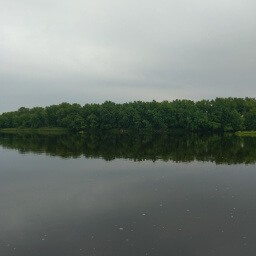
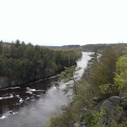
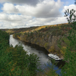
Only an hour away from the Twin Cities, this state park is a great escape into nature. The St. Croix River is a federally designated Wild and Scenic River thanks to the eponymous act of Congress in 1968 protecting 8 rivers throughout the nation. This limits development near the river, leaving a pristine natural environment perfect for recreation. Combining this with the distance from major highways, you can enjoy the peace and beauty here without traveling far.
Dogs are allowed on leash. While this particular route is not family friendly, most of the trails in the park have flat terrain and can be completed as short loops. Some alternatives are the 1.2 mile Amador Prairie Loop, the approximately 2.3 mile Hiking Club Loop, or the 1.4 mile River Terrace Loop. Much of this trail is groomed for skiing in the winter and hiking is not allowed. I went on a Friday afternoon and saw only a few people plus one large group on horseback in the prairie; I doubt this experience is standard on the weekends however, so expect greater numbers. You can access this route from all of the parking lots except for the ones near the campgrounds in case parking is full at any of the lots. This also allows you to modify your starting position based on when you want to do the shadeless prairie portion of the hike (important on a hot day).
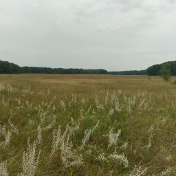
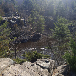
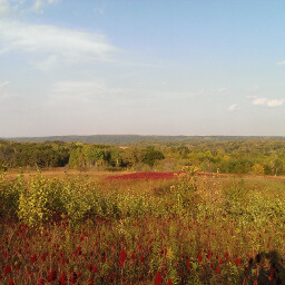
From the parking lot, follow signs near the building pointing east for the Amador Prairie Loops. At the first intersection, turn right. The trail soon leads to a large restored prairie (as you might have guessed from the trail name). Depending on the time of year, many different types of flowers bloom here such as daisies, coneflowers, and goldenrods. Turn right at the next intersection, then turn right again at the following intersecion where signs point to the Nevers Dam Trail -- the picture below was taken here.

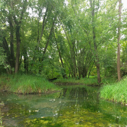
You will see countless green northern leopard frogs while hiking along the St. Croix River
View full size
The wide variety of landscapes and the relatively easy but long trail makes this an excellent destination hike. The St. Croix River is a stunning spectacle, and the restored prairie is pretty. The best part is this park is close to the Twin Cities, so you can easily escape to enjoy nature. Let me know what you think in the comments section below and be sure to use #nocoastbestcoast on Twitter and Instagram!
Hiked on Friday, August 18th, 2017 by Ricky Holzer
Directions
From the Twin Cities, take Interstate 35 north to County Road 19 in Stacy, then turn right. Soon, turn left on Forest Boulevard, and later turn right on County Road 18 (Lent Trail). Turn right on Lincoln Road, then turn left on County Road 15. Turn right on Minnesota Highway 95, then immediately turn left on County Road 12 (Park Trail). Follow this road straight to the park entrance. Pay your fee at the office on the right, then turn left ahead to park at the trail center/horse camp area.
Google Maps Directions
Parking, Fees, and Facilities
Like all Minnesota State Parks and Recreation Areas, you must pay a vehicle entry fee of $7 per day or $35 for an annual pass (highly recommended if you frequently go to Minnesota State Parks). There is a large building with restrooms near the lot.
Nearby Hikes
Interstate State Park, Minnesota
★★★★☆(4/5)
Interstate State Park, Minnesota
★★★★☆(4/5)
Interstate State Park, Wisconsin
★★★★★(5/5)
William O'Brien State Park, Minnesota
★★★★☆(4/5)