| Rating | ★★★★☆(4/5) |
| Overall Difficulty | Moderate |
| Navigation Difficulty | Easy |
| Distance | 3 miles roundtrip |
| Time | 1.5 hours |
| Terrain | Hilly |
| Best Seasons | Spring, Summer, Fall |
| Dog Friendly | Yes |
| Accessible | No |
Highlights
- Meadows and ponds galore
- Exciting trail with many ups and downs and twists and turns
- Interpretive signs along Ogechie Lake
Hike Summary
This is one of the better Hiking Club trails taking you up and down rolling terrain and twisting and turning through gorgeous forest. Even though this park is only 2 hours north of the Twin Cities, the forest is markedly different featuring more varied topography and diverse trees, both coniferous and deciduous. I can imagine this is a stunning place in the fall with such a variety of plants changing colors. This park is also the 4th largest by area out of all Minnesota State Parks and as such gives a wilderness feeling without being far from civilization or modern comforts.
Dogs are allowed on leash. Although most Hiking Club hikes are family friendly, this trail is longer and hillier and may not be suited for younger children; check out the Hiking Club Loop at Father Hennepin State Park for an easier but similar hike at a park also on Mille Lacs Lake. Bring your bug spray or face the wrath of the mosquitos. Also, it is especially important that you pick up a park map from the park office to help you navigate the many intersections and turns required to complete this loop.
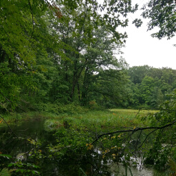
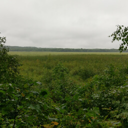
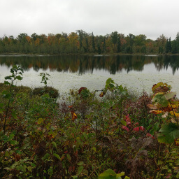
A portion of this trail requires you walk along the road, and I recommend you get this part out of the way first so you can enjoy the rest of your hike. From the parking lot, follow the park road until it meets a trail on your left. Take the trail, then turn right at the following intersection marked 19 with a sign and on the map -- the rest of the intersections on this hike are also numbered and signed to help you navigate. At intersection 23 ahead, turn left, then continue straight through intersection 24. This section of trail has rolling hills, and openings in the trees will offer you beautiful views of meadows and ponds like pictured below and at the top of the page.
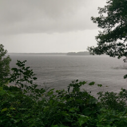
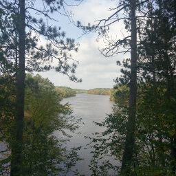
Turn right at intersection 16. After a half mile you will reach intersection 17 where you will have two options: go to the right to follow the Landmark Trail along Ogechie Lake to see the Wilford Site (historical marker), or head left for a series of expertly placed educational signs that explain the different types of forest that have existed here over time with real live tree examples of that era nearby (I've become a bit of a nerd about forest ecosystems lately, so I obviously opted for the educational trail on the left). Eventually the two trails meet up and you will have views of the lake on your right as pictured below. At intersection 18, continue straight, and the trail loops around back to the parking lot after passing the Cooper Site. Overall, this is a really enjoyable trail and is worthwhile even if you aren't collecting Hiking Club passwords. This is a great introduction to the park, and hopefully this hike encourages you to try other trails -- this state park is so large that there are still many other trails left to explore. Let me know what you think in the comment section below and be sure to use #nocoastbestcoast on Twitter and Instagram!
Hiked on Saturday, August 26th, 2017 by Ricky Holzer
Directions
From the Twin Cities, take Interstate 94 west to Rogers, then take the exit for Minnesota Highway 101 north. Continue straight and the highway changes into U.S. Highway 169. A few miles after the highway hits Mille Lacs Lake, follow the sign for Mille Lacs Kathio State Park and turn left onto Shakopee Lake Road. Turn right onto Kathio State Park Road. Pay the entrance fee at the park office on the right, then continue on the main park road. Turn right at the Y intersection ahead, then park in the lot where the road ends.
Google Maps Directions
Parking, Fees, and Facilities
Like all Minnesota State Parks and Recreation Areas, you must pay a vehicle entry fee of $7 per day or $35 for an annual pass (highly recommended if you frequently go to Minnesota State Parks). There are vault toilets near the lot.
Nearby Hikes
Father Hennepin State Park, Minnesota
★★★☆☆(3/5)
Crow Wing State Park, Minnesota
★★★★☆(4/5)
Rice Lake National Wildlife Refuge, Minnesota
★★★★☆(4/5)
Banning State Park, Minnesota
★★★★★(5/5)