| Rating | ★★★★☆(4/5) |
| Overall Difficulty | Hard |
| Navigation Difficulty | Easy |
| Distance | 5.5 miles roundtrip |
| Time | 2.5 hours |
| Terrain | Hilly |
| Best Seasons | Summer, Fall |
| Dog Friendly | No |
| Accessible | No |
Highlights
- Challenging hills
- Peaceful forest
- Short boardwalk through marsh
Hike Summary
Murphy-Hanrehan Park Reserve is yet another excellent Three Rivers Park District property. The terrain here provides a challenging hike and frequent twists and turns keep you captivated. And the best part is you don't even have to leave the Twin Cities!
Dogs are not allowed on most unpaved trails in Three Rivers Park District parks; as an alternative, there is a giant off leash dog area adjacent to this parking lot and dogs are allowed on the trails in the southern portion of the park starting at the Minnregs Trailhead. The trails in this portion of the park are probably too hilly and difficult for small children, so for a family friendly option head to the Minnregs Trailhead and do a loop around Minnregs Lake. About half of this route is closed to all users from April 1 to August 1 (shown as a dotted line on the official map linked below), and the entire route is closed to hikers and snowshoers in winter to leave room for skiers. I hiked here on a late Saturday morning, and saw only a few people and was alone for quite a while in the parts furthest from the trailhead. Given the difficulty and distance of the trail, I wouldn't ever expect a crowd here.
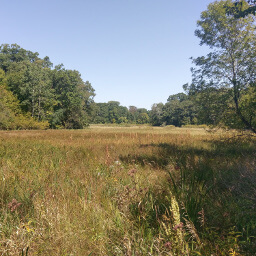
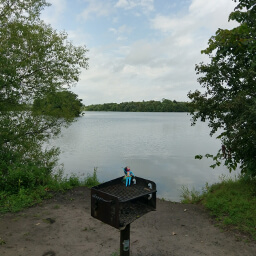
This hike is a loop, and there are no specific scenic destinations to persuade you to go clockwise or counterclockwise. Do whatever way you feel, but I will now describe the route I took using the numbered intersections on the official map linked below (note that a portion of the trail is missing on that map at the time of writing). From the parking lot, head south on the trail past the bathroom and stay right at the split. Continue straight through intersections 22, 11, and 10. The trail in this section has rolling hills and dense forest. Just before intersection 18, you will see the small lake pictured at the top of the page. After hiking through dense forest, you will really appreciate the lakes and prairie in between that provide the best views.
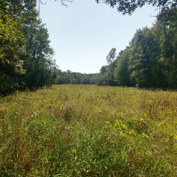
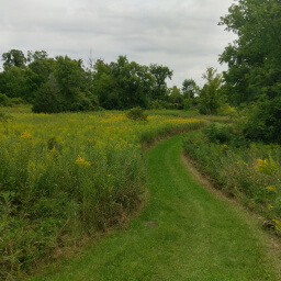
Turn right at intersection 18 and stay right at intersection 9 (but don't turn right onto the closed trail indicated by signs). This section of trail has the longest hill climbs of the whole route, and you'll probably break a sweat here (if you haven't already). Stay left at intersections 8 and 7. At some point you will pass the prairie pictured below.
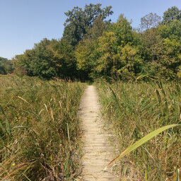
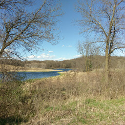
After the bench, you will begin descending a hill down to a wetland with a short boardwalk, see the two pictures below. Enjoy this little diversion from the hilly hike because right after the boardwalk you have to climb uphill again. The last portion of the trail closely follows the shoreline of Hanrehan Lake. Most of the views are blocked by trees, and the lakefront houses in the background spoil the few unobstructed views you have. Stay right at intersection 1, then continue back to the parking lot. If you're like me, you'll probably want to stop for a solid meal on the way home. All of those hills provide an unexpected challenge in the Twin Cities, especially when you're used to flat hikes around lakes. Let me know what you think in the comments section below, and be sure to use #nocoastbestcoast on Twitter and Instagram!
Hiked on Saturday, September 9th, 2017 by Ricky Holzer
Directions
From Minneapolis, take Interstate 35W south and exit at Burnsville Parkway. Turn left, then turn right at a stop sign ahead to stay on Burnsville Parkway. Continue straight until the traffic circle, then follow the circle to the park entrance on the left. Park in the lot on the left.
From St. Paul, take Interstate 35E south and exit at County Road 42. Turn right, then turn left on Burnsville Parkway. Continue straight until the traffic circle, then follow the circle to the park entrance on the left. Park in the lot on the left.
Google Maps Directions
Parking, Fees, and Facilities
Parking is free at all Three Rivers Park District parks and trails. There is a vault toilet and a map kiosk with free paper maps near the lot.
Nearby Hikes
Murphy-Hanrehan Park Reserve, Minnesota
★★★★☆(4/5)
Hyland Lake Park Reserve, Minnesota
★★★☆☆(3/5)
Anderson Lakes Park Reserve, Minnesota
★★★☆☆(3/5)
Hyland Lake Park Reserve, Minnesota
★★★☆☆(3/5)