| Rating | ★★★★★(5/5) |
| Overall Difficulty | Easy |
| Navigation Difficulty | Easy |
| Distance | 1.5 miles roundtrip |
| Time | 45 minutes |
| Terrain | A few hills |
| Best Seasons | All |
| Dog Friendly | Yes |
| Accessible | No |
Highlights
- Scenic views of Lake Superior
- Rocky cliffs and bluffs
- Waterfront access
Hike Summary
This is probably one of the best hikes along the North Shore of Lake Superior in Minnesota: it's short with just enough up and down to keep you entertained but not out of breath and has stunning views throughout. Compared to the other hikes in the park, this hike is easy and doesn't have the same amount of uphill as other scenic hikes like High Falls and Two Step Falls.
Dogs are allowed on leash, and since the rocky shore of Lake Superior is not designated as a beach, your dog is free to play in the water. The short distance makes this a good family friendly hike, just watch so your kids do not wander too close to the cliff edge.
From the visitor center, follow the trail along the cliff's edge heading northeast. Once you leave the area near the visitor center, there will be no trail intersections to worry about for the remainder of the hike, so continue going straight. There will be some sections with boardwalks or stairs -- be sure to use these to protect the surrounding vegetation and prevent erosion. Near the end of the trail at Shovel Point, the trail will split. It doesn't matter which direction you choose because this section is a loop. At Shovel Point, enjoy the views like shown in the picture above and below. If you look to the southwest, you can see Palisade Head; this rock formation on Lake Superior is also part of Tettegouche State Park and you can drive to the top (the access road is just south of the visitor center on Minnesota Highway 61) to enjoy additional views.
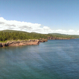
The cliffs looking northeast from Shovel Point
View full size
Hiked on Saturday, July 2nd, 2016 by Ricky Holzer
Directions
From Duluth, take Minnesota Highway 61 north for a little over one hour. Watch for signs for Tettegouche State Park, and there will be a large parking lot in front of the visitor center on the right.
Google Maps Directions
Parking, Fees, and Facilities
The visitor center off the highway also functions as a rest area, so parking is free for day use, but note that overnight parking or parking in any other lots in the park require you pay the vehicle entry fee. The visitor center has bathrooms (open 24/7/365), a gift shop, and educational exhibits about wildlife. There are also many picnic tables nearby.
Nearby Hikes
Tettegouche State Park, Minnesota
★★★★★(5/5)
Tettegouche State Park, Minnesota
★★★☆☆(3/5)
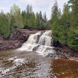
Gooseberry Falls State Park, Minnesota
★★★★★(5/5)
Gooseberry Falls State Park, Minnesota
★★★★★(5/5)