| Rating | ★★★★☆(4/5) |
| Overall Difficulty | Moderate |
| Navigation Difficulty | Easy |
| Distance | 5 miles roundtrip |
| Time | 2 hours |
| Terrain | Hilly |
| Best Seasons | All |
| Dog Friendly | Yes |
| Accessible | No |
Highlights
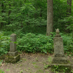
- Historic markers to learn about Forestville's past
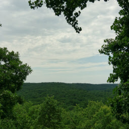
- Views from the overlook
- Costumed performers reenact life in 1899
Hike Summary
The Town of Forestville is a prime example of an agricultural trade center that developed in the early days of Minnesota settlement. The railroad bypassing the town sealed its eventual decline, and Thomas Meighen, who owned the entire village by the turn of the century, proposed creating the state park you see here. This is a truly unique hike with filled with rich history and pretty nature.
While the entire loop described here is too long and hilly for most children, the main attractions of Forestville are all a short distance from the parking lot and can be enjoyed by anyone. Dogs are allowed on leash on all the trails, but not allowed in buildings. One major note about this park is that it has the highest horseback use of any Minnesota State Park. Keep an eye out for horse droppings, and give horseback riders space to pass.
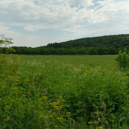
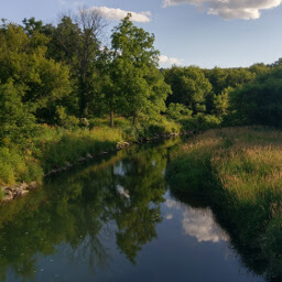
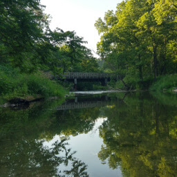
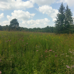
From the parking lot, follow the trail near the kiosk to the old bridge across the South Branch Root River. The buildings that still stand, like the one pictured above, are all located in around the same area on the other side of the bridge. Continue walking straight on the dirt road after crossing the bridge. All of the other historic sites you see on the official map linked below are informational signs about the site next to an overgrown foundation (or nothing at all in some cases). If you are a history buff or the type who likes to read about everything, walk along the dirt road to see the historic sites. Otherwise, take the River Bottoms Trail for a beautiful, flower filled walk through prairies that have replaced former farm fields (pictured below); turn right when you loop back to the dirt road.
Here, signs will inform you that this entire forest used to be oak savanna (notice the gnarly old oak trees lining this trail!), a transition zone between the Great Plains and the forests of the east that is much grassier than the overgrown environment you see here today. One contributing factor is the loss of bison and deer in the area that ate the plants and young trees on the forest floor. Prescribed burns and armies of goats (like at the University of Wisconsin-Platteville) are two methods used in the Midwest to restore oak savanna. Head back to the split in the trail and turn left to follow the Sandbank Trail back to Forestville and the parking lot. After your hike, be sure to check out the programs offered in Forestville. Visit the Minnesota Historical Society website for more information about Historic Forestville and the events and programs they offer. From Memorial Day to Labor Day, costumed characters guide visitors for an $8 admission for adults and $6 for children 5-17 (children 4 and under are free), seniors, and college students. Signature events hosted here include Bread Making day, Apple Cider Pressing Day, and the 1899 Independence Day Celebration.
I hope your hike was thoroughly educational. As always, use the comments section below to let me know how you enjoyed your trip and remember to use #nocoastbestcoast on Twitter and Instagram!
Hiked on Sunday, July 9th, 2017 by Ricky Holzer
Directions
Be careful when using navigation to direct you to this park! You must enter the park from the west side using County Road 118 after turning from County Road 5; otherwise if you enter from the north, you will run into a dead end at a closed bridge and will be unable to access the rest of the park.
From the Twin Cities, take U.S. Highway 52 south towards Rochester. On the south side of Rochester, take the exit for U.S. Highway 63 heading south. At the T intersection a bit after Racine, turn left to continue on U.S. Highway 63. Then in Spring Valley, continue heading straight onto Minnesota Highway 63 rather than staying on U.S. Highway 63. Turn right on County Road 5, then turn left on County Road 118 following the signs for Forestville State Park. The park office will be on the right hand side. Pay your fee, then continue straight on the main park road and park in the third parking lot on the left side. If you reach a dead end at a closed bridge, turn around and look for the next driveway to a parking lot.
Google Maps Directions
Parking, Fees, and Facilities
Like all Minnesota State Parks and Recreation Areas, you must pay a vehicle entry fee of $7 per day or $35 for an annual pass (highly recommended if you frequently go to Minnesota State Parks). Historic Forestville is a short walk from the parking lot across the pedestrian-only bridge. Flush toilets and covered picnic area are located near the other parking lot only a short walk away via trail.
Nearby Hikes
Forestville-Mystery Cave State Park, Minnesota
★★★★☆(4/5)
Forestville-Mystery Cave State Park, Minnesota
★☆☆☆☆(1/5)
Forestville-Mystery Cave State Park, Minnesota
★★★★★(5/5)
Oxbow Park, Minnesota
★★★★☆(4/5)