| Rating | ★★★★☆(4/5) |
| Overall Difficulty | Moderate |
| Navigation Difficulty | Easy |
| Distance | 4 miles roundtrip |
| Time | 2 hours |
| Terrain | A few hills |
| Best Seasons | All |
| Dog Friendly | Yes |
| Accessible | No |
Highlights
- Sheer limestone cliffs towering over crystal clear water
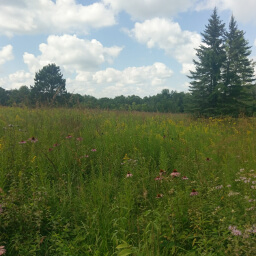
- Interesting convergence of tallgrass prairie and eastern deciduous forest biomes
Hike Summary
Although I haven't walked every single mile of trails in this park, I will preemptively declare this as the best hike in the park. The nature is remarkably different from the surrounding area, and the water of the Canfield Creek and South Branch Root River is impressively clear -- it doesn't matter how deep it gets, you can always see the bottom.
Dogs are allowed on leash. Although this hike isn't labeled family friendly, older children capable of hiking 4 miles roundtrip will definitely enjoy this trail. I did this hike on a late Saturday afternoon and only saw a handful of other people, and I doubt this trail is ever crowded even during the peak times of the day. This park has the most horseback riders of any Minnesota State Park, so watch your step on this trail and give riders space to pass when you encounter them.
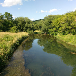
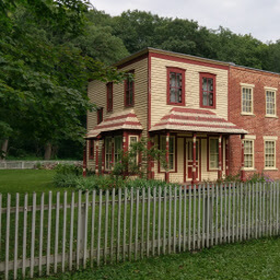
Navigating this hike is straightforward, mostly because the trail is basically a line heading south. From the parking lot, head towards the amphitheater, then follow the trail south through a tall patch of fennel. At the trail intersection after passing the cabins, stay left. After a short downhill then uphill section, turn left (there should be signs here saying "No Horses"). Continue on the trail to a bridge over the South Branch Root River, and stop to marvel at the beauty around you that looks much like the picture below and the picture at the top of the page.
Near the end of the hike, there is normally a bridge to cross the creek. When I visited, the bridge had been moved completely on land, so I had to take my shoes and socks off and ford the creek. It may have been the middle of summer, but this water was icy cold! This added a little bit of thrill to the hike, and if you're lucky you'll get to watch the shocked faces of other adventurous hikers as their feet touch the water.
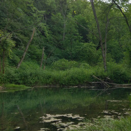
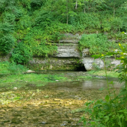
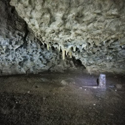
The hike ends rather abruptly with a dead end at Big Spring. Initially you'll probably see the creek that you've been walking next to this entire hike (like pictured below) and think, "This is it?" Then, you look up and realize there is a towering vertical cliff in front of you -- I tried so hard to photograph this for you, but the cliff is too tall to fit in one frame. You'll also see the small cave at the bottom of the cliff (second picture below). Once the adrenaline dies down from the freezing barefoot creek crossing, you can actually enjoy this peaceful place: the gentle sounds of running water free of road noise and the wall of rock in front of you. Simply retrace your steps to return to the parking lot. When you're done, I have no doubt that you will agree this is the best hike in the park. Let me know what you think using the comment section below, and be sure to use #nocoastbestcoast on Twitter and Instagram!
Hiked on Saturday, July 8th, 2017 by Ricky Holzer
Directions
Be careful when using navigation to direct you to this park! You must enter the park from the west side using County Road 118 after turning from County Road 5; otherwise if you enter from the north, you will run into a dead end at a closed bridge and will be unable to access the rest of the park.
From the Twin Cities, take U.S. Highway 52 south towards Rochester. On the south side of Rochester, take the exit for U.S. Highway 63 heading south. At the T intersection a bit after Racine, turn left to continue on U.S. Highway 63. Then in Spring Valley, continue heading straight onto Minnesota Highway 63 rather than staying on U.S. Highway 63. Turn right on County Road 5, then turn left on County Road 118 following the signs for Forestville State Park. The park office will be on the right hand side. Pay your fee, then turn right following signs for the amphitheater. Turn right again towards the amphitheater and park in the lot on the right side -- if you hit the campground loops you've gone too far.
Google Maps Directions
Parking, Fees, and Facilities
Like all Minnesota State Parks and Recreation Areas, you must pay a vehicle entry fee of $7 per day or $35 for an annual pass (highly recommended if you frequently go to Minnesota State Parks). There are pit toilets near the amphitheater.
Nearby Hikes
Forestville-Mystery Cave State Park, Minnesota
★☆☆☆☆(1/5)
Forestville-Mystery Cave State Park, Minnesota
★★★★☆(4/5)
Forestville-Mystery Cave State Park, Minnesota
★★★★★(5/5)
Oxbow Park, Minnesota
★★★★☆(4/5)