| Rating | ★★★★☆(4/5) |
| Overall Difficulty | Moderate |
| Navigation Difficulty | Easy |
| Distance | 5.5 miles roundtrip |
| Time | 2.5 hours |
| Terrain | Mostly flat |
| Best Seasons | Spring, Summer, Fall |
| Dog Friendly | Yes |
| Accessible | No |
Highlights
- Riverside scenery
- Perfect lunch spots
Hike Summary
St. Croix State Park is the largest of all Minnesota State Parks, a vast swath of forest along the St. Croix River. Unlike the St. Croix blufflands further south, the landscape here is mostly flat and the river is calmer and narrower. On the adventurous drive through the forest required to access this trailhead, you should visit the fire tower -- you pass the access road for it anyway -- and climb above the forest canopy to observe the wide reach of this wilderness. This hike gives you a taste of the pretty pines and wetlands you will find near the river's edge.
Dogs are allowed on leash. This trail, like many others in this giant park, are too long to be family friendly; rather than doing this hike, there are several stops along this park road that only require a short walk at most to view beautiful scenery: the fire tower, Kettle River Highbanks, Kettle River Overlook, and Head of the Rapids. This trail is unavailable during the winter months but may be hiked the rest of the year. I visited on a gorgeous Saturday afternoon, and the parking areas were all completely full, so I had to park on the side of the road. I saw a good amount of people on the portion of trail along the Kettle River, but didn't see another soul while walking along the St. Croix River.
Unless you are willing to add an additional mile to your hike, this route requires you walk along the road for an entire mile (it's probably worth it to add the extra mile and skip this part). In the tradition of saving the best part for last, I recommend doing the walk on the road first, so head east on the road from the parking area. The alternative route would be to take the Bear Creek Trail, which starts near the parking area and heads northeast, following the trail straight for 2 miles until you reach the road. No matter which route you take, you will eventually reach a trail on the south side of the road.
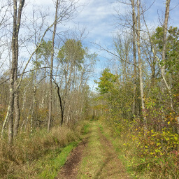
Major bummer alert: this next 1.1 mile section of trail is also uneventful, though much more pleasant than walking on a road. The trail is pretty straight and looks like the picture below for the entire section, wide with a slight decline as you hike toward the river. Stay left at the intersection ahead (where you can finally see the river!) and continue to the campsite ahead.
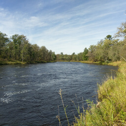
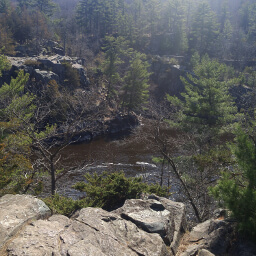
The next mile can be wet and muddy, especially after recent rains. The surrounding wetland environment is a good break from the forest, and you will have several peeks through the tall grasses and trees to give you views like pictured at the top of the page. The trail comes to a point at the Two Rivers Campsite, your other lunch spot option. There are a couple benches, but they are likely to be occupied at lunchtime on a weekend. If you don't mind sitting directly in the sun, you can sit at the point where you watch the Kettle River converge with the St. Croix River. All of this flowing water is quite lovely, but also unphotogenic (hence why I haven't shared any pictures of it with you).
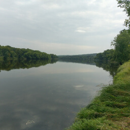
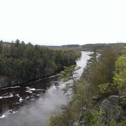
From the point, follow the trail directly north along the Kettle River. Your views for the rest of the 1.8 miles back to the parking area will look like the picture below. This section is also more crowded than the previous portions because a 3.6 mile riverside hike to the point and back seems like a much nicer journey to most people than enduring 2 throwaway miles just to see a bit more of the St. Croix. Well, that was a hike. If you still have energy, stop by the Kettle River Highbanks on the drive out of the park for tremendous views of the Kettle River. Otherwise, let me know what you think in the comments section below and be sure to use #nocoastbestcoast on Instagram and Twitter!
Hiked on Saturday, September 2nd, 2017 by Ricky Holzer
Directions
From the Twin Cities, take Interstate 35 north to Hinckley and take the exit for Minnesota Highway 48. Turn right and continue heading east on Minnesota Highway 48. Look for the signs marking the park entrance about 15 miles from Hinckley, and turn right. Pay the fee at the park office on the right, then turn right at the intersection ahead. The journey to the trailhead takes you on a narrow, winding road through the forest which is dirt/gravel for a majority of the distance (doable in a sedan, just drive slowly). Follow signs pointing toward the Head of the Rapids at every intersection until you reach a small parking lot at the Kettle River Overlook.
Note, at the time of writing Google Maps thinks the trailhead location is inaccessible by car, so do not trust the directions given by clicking the link below!
Google Maps Directions
Parking, Fees, and Facilities
Like all Minnesota State Parks and Recreation Areas, you must pay a vehicle entry fee of $7 per day or $35 for an annual pass (highly recommended if you frequently go to Minnesota State Parks). There are no facilities at this lot.
Nearby Hikes
Banning State Park, Minnesota
★★★★★(5/5)
Wild River State Park, Minnesota
★★★★☆(4/5)
Interstate State Park, Minnesota
★★★★☆(4/5)
Interstate State Park, Minnesota
★★★★☆(4/5)