| Rating | ★★★★☆(4/5) |
| Overall Difficulty | Easy |
| Navigation Difficulty | Easy |
| Distance | 3.9 miles roundtrip |
| Time | 1.5 hours |
| Terrain | A few hills |
| Best Seasons | All |
| Dog Friendly | Yes |
| Accessible | No |
Highlights
- Hilltop prairie views
- Overlook of the lake with benches
- Boardwalk through marsh
Hike Summary
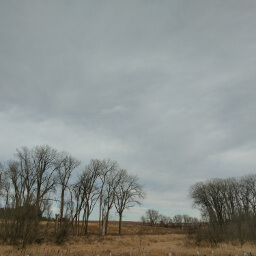
Nestled in the rural fringe of the Twin Cities between two major highways, this park is easily accessible yet still tranquil. With state owned wildlife management areas on the south and east sides, the park feels bigger than it actually is. The rolling terrain here is particularly beautiful, and there are multiple viewpoints along the trail to enjoy that sprawling countryside. Despite those hills, the trails here were masterfully designed to minimize the amount of effort required to hike up and down.
Dogs are allowed on leash. This hike is on the long side of the family friendly spectrum, but the trail is really gentle on the hills. You can shorten the hike to an even 3 miles if you cut out the side hike to an overlook (the bit sticking out of the loop on the bottom left corner on the map above). I specifically followed the route that permits hiking all year, since the rest of the trails are groomed for cross country skiing in winter and do not allow hikers to trample that powder. I hiked on a particularly warm Saturday afternoon in early December, and the parking lot was about 1/3 full with people scattered around the park trails. Expect many more people in the summer.
From the parking lot, follow the paved trail starting near the map kiosk heading west. The intersections here are all labeled with a number corresponding with the official park map so you can easily locate yourself; you can also download the PDF of the map to your smartphone and use the Avenza Maps app to see your actual location. The intersection is 22 where you start, then you will gradually snake down the hill -- seriously though, the incline here is so slight you wonder why they decided to build switchbacks here in the first place (I take back the "masterfully designed" statement from before). Be a good citizen and follow the pavement rather than cutting through the fragile prairie grass; the people hiking behind me had the nerve to cut the switchbacks when they could obviously see I was following the path properly and they ended up tailgating me while I tried to powerwalk away. Ahead you will see Empire Lake for the first time, pictured below, and you have the choice to go straight or right to begin the loop at intersection 21. Frustratingly, the tailgaters behind me also had this choice and they still chose to follow me going straight.
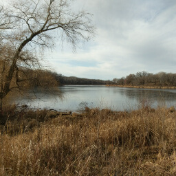
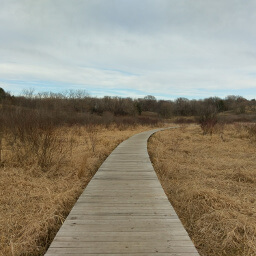
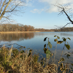
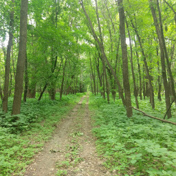
There are a couple more small hills ahead, then you have the option to take a 0.8 mile roundtrip side quest to an overlook at intersection 3 -- note that this distance is included in the total distance at the top of the page. This side trail is definitely worth the extra mileage and slight hill climbing because you earn the view pictured below. Once you return back to the main trail, turn left to continue the hike. In a quarter mile, you will begin walking on the boardwalk across the marsh pictured below. The boardwalk is relatively new, and much like at Lebanon Hills Regional Park, this is more evidence of Dakota County's commitment to maintaining high quality parks. After the boardwalk at intersection 4, the trail splits and winter hikers must head to the right; even in the warm seasons, you should still go right because there is a lovely overlook of Empire Lake with a couple benches. Of course, there is some slight uphill to reach the view, but like the rest of the hike it's not very difficult. Eventually you will see the pretty view pictured at the top of the page.
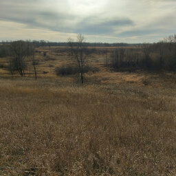
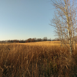
The trail bends to the northwest shortly after you pass the overlook, and you will see the section of prairie pictured below and a forest of newly planted trees protected by plastic tubes. Continue straight at the next intersection, and you are on the home stretch! The remainder of the hike is mostly flat and isn't particularly noteworthy. At intersection 19, you can choose to turn left for a strong hilly finish to the hike, or you can continue straight and turn left at intersection 21 to retake that paved snake back uphill. I took the former option just to shake things up a little. All in all, this park is a wonderful place for some nature time and offers great scenery. While the hike is easy, it's still long enough that you can feel accomplished. Let me know what you think in the comments section below and be sure to use #nocoastbestcoast on Twitter and Instagram!
Hiked on Saturday, December 2nd, 2017 by Ricky Holzer
Directions
From Minneapolis, take Minnesota Highway 77 south to Apple Valley, then turn left on 160th Street (County Road 46). Follow signs for Whitetail Woods Regional Park and turn right on the dirt road Biscayne Avenue. Turn left on 170th Street, then turn right on Station Trail. Turn right again after the road bends and starts heading due east and continue to the parking lot.
From St. Paul, take U.S. Highway 52 and exit at County Road 46 (Brandel Drive). Turn left, then turn left again on Blaine Avenue. Turn right onto 170th Street, then turn left on Station Trail. Turn right after the road bends and starts heading due east and continue to the parking lot.
Google Maps Directions
Parking, Fees, and Facilities
Parking is free! There are flush toilets, a covered picnic area, fire pit, and a playground near the trailhead.
Nearby Hikes
Lebanon Hills Regional Park, Minnesota
★★★★☆(4/5)
Minnesota
★★★☆☆(3/5)
Murphy-Hanrehan Park Reserve, Minnesota
★★★★☆(4/5)
Minnesota Valley National Wildlife Refuge, Minnesota
★★★★☆(4/5)